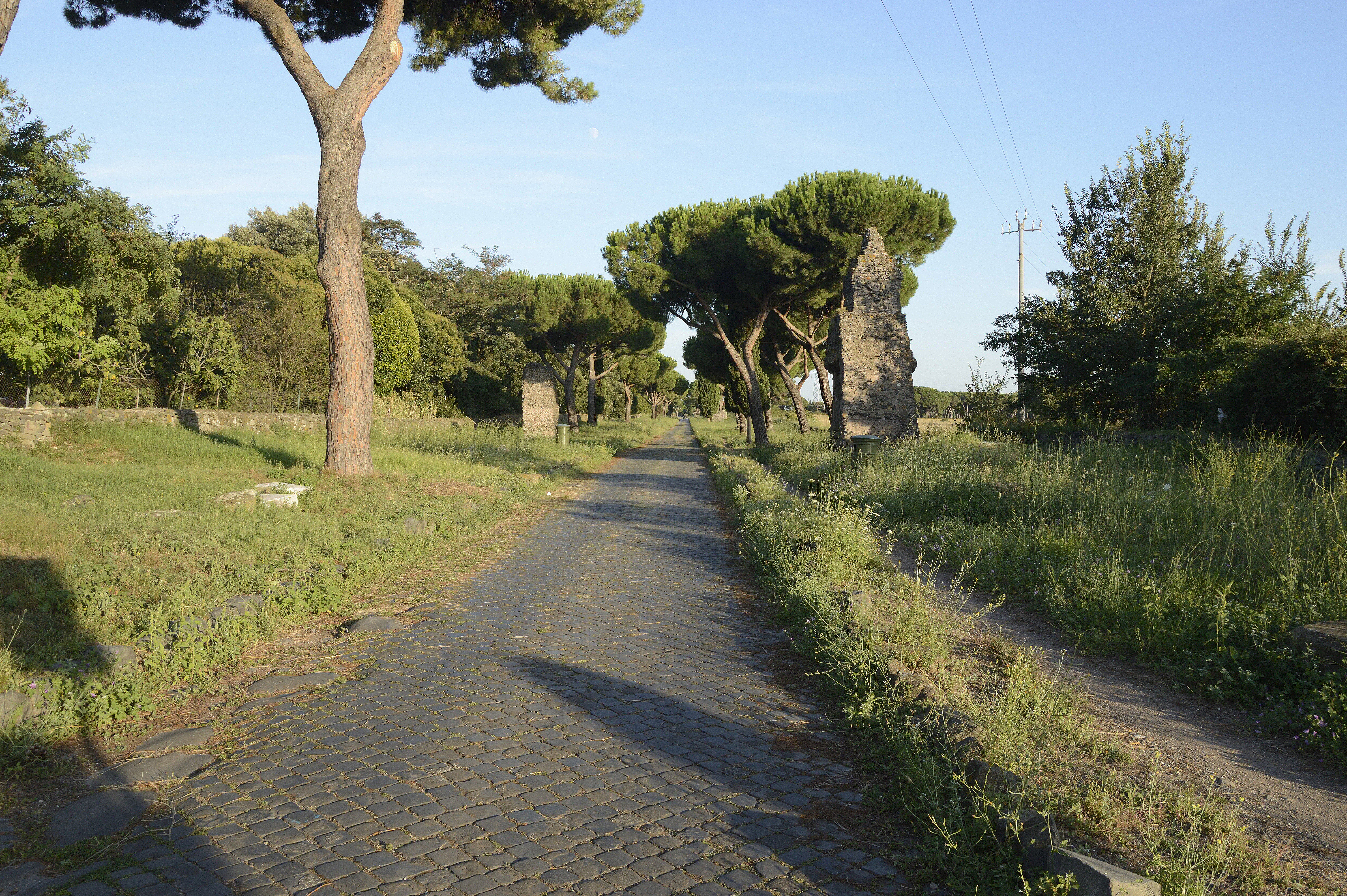
The Road and Its Traffic History
The Via Appia was commissioned in 312 BC by Censor Appius Claudius Caecus to connect Rome with Capua, and subsequently extended to Brindisi (Brundisium) on the Adriatic coast. For six centuries it was the primary military and commercial artery of the Italian peninsula's western flank. Roman milestones, set at one-mile intervals from the Porta Capena in Rome, provided the infrastructure for a layered system of rest stops: tabernae (commercial rest stops offering food and lodging) at shorter intervals, and mutationes (horse-relay stations) at roughly 10–15 mile intervals.
By the 5th century AD, the road's commercial importance had diminished significantly as sea traffic and newer imperial roads redistributed traffic flows. The section closest to Rome — the first 20 km south of the city, running through the Agro Romano — retained some use as a local agricultural road but lost its through-traffic function almost entirely by the 7th century. This early abandonment is precisely why the road margins were not subsequently redeveloped, leaving the roadside structures in a state of arrested decay rather than active demolition and reuse.
The Appian Way near Casal Rotondo, Rome. Photo: Wikimedia Commons (CC BY-SA 4.0).
Roman Tabernae: What the Archaeology Shows
The Roman taberna on a consular road was not merely a tavern — it was a standardised commercial rest stop typically occupying a rectangular plot of roughly 10 × 20 metres, with a street-facing colonnade, a main room combining serving and sleeping functions, a rear storage area, and, in the larger examples, a separate stable court. The architectural type is well documented from Pompeii and Ostia, and field surveys along the Via Appia have identified at least 34 sites where foundation footprints matching this plan survive either as visible masonry or as cropmark patterns in aerial photography.
The concentration is highest in the stretch between the 3rd and 8th milestones from Rome, corresponding to the densely settled zone of the early imperial period. Beyond the 10th milestone, tabernae become less frequent, replaced by the larger mutationes at road junctions and river crossings. The best-preserved taberna remains in this zone are at the site known as Frattocchie, near the 12th milestone, where three courses of opus reticulatum facework survive above ground level and have been dated by LIDAR survey to the 1st century AD.
Medieval Conversion: Mausoleums into Oratories
The most distinctive feature of the Via Appia rest-stop sequence in the medieval period is the systematic conversion of Roman roadside mausoleums into Christian oratories. The Via Appia's margins are lined with mausolea — Roman aristocratic tomb towers, typically of cylindrical or square plan, built in substantial concrete and stone and designed to be permanent landmarks. Their structural solidity and roadside position made them ideal for conversion into shelter points once their original commemorative function had lapsed.

Torre Selce on the Via Appia Antica: a 12th-century tower built on a Roman mausoleum, serving as a fortified waystation in the medieval period. Photo: Wikimedia Commons (CC BY-SA 4.0).
Torre Selce is the most complete surviving example. The Roman cylindrical mausoleum at this location, dating from the 1st or 2nd century AD, was converted into a watchtower and waystation in the 12th century — the documentary record confirms its existence as a torre-ospizio in a 1148 grant from Pope Eugene III to the Caetani family. The current upper structure is entirely medieval, but the lower third retains its Roman concrete drum. Similar sequences — Roman foundation, medieval superstructure — have been documented at Casal Rotondo (km 12.4), Torre di Capo di Bove (km 8.8), and at least four other points on the first 20 km of the road.
Wayside Oratories: Distribution and Typology
Beyond the immediate Roman suburbs, the Via Appia's medieval rest-stop network consisted primarily of oratories rather than staffed hospices. The road's reduced commercial importance meant there was insufficient traffic to sustain the larger institutional types. Instead, a series of single-nave oratories — most between 6 and 14 metres in length — occupied positions at road junctions, spring sites, and the ruins of more substantial Roman structures.
The distribution of documented medieval oratories along the first 50 km of the Via Appia shows a spacing of roughly 4–6 km between points — consistent with a day's walking pace divided into two or three segments with rest stops. This spacing is not accidental: several 12th and 13th-century episcopal charters granting endowments for oratory construction specify that the new structure should be within sight or sound (within earshot of a bell) of the previous one.
The most notable concentration is in the stretch between Velletri and Terracina, where the road crosses the Pontine plain — a zone notorious in ancient and medieval sources for its unhealthy climate and lack of natural shelter. Here, the oratory network was supplemented by a documented series of elevated timber platforms — covered resting places raised above the marsh surface — attested in a 1243 letter from Pope Innocent IV authorising their construction along this section. No physical trace of these structures survives, but their existence is supported by the unusual concentration of endowment documentation for this specific stretch.
Milestone Inscriptions and Itinerary Evidence
The Roman milestones of the Via Appia — some 200 of which have been documented along the route — provide a secondary layer of information about rest-stop locations. Several milestones bear additional inscriptions beyond the standard distance notation, including references to nearby mansiones (official rest stations for imperial couriers) and, in the later imperial period, to the distances to the nearest hospitium.
The Itinerarium Antonini, a 3rd-century road guide covering the main routes of the Roman Empire, lists 15 stopping points between Rome and Capua on the Via Appia. Cross-referencing these with the medieval oratory distribution suggests a high degree of continuity: 11 of the 15 Antonine stopping points coincide with documented medieval oratory sites, supporting the inference that the traveller's logic of where to stop changed little between the Roman and medieval periods — what changed was the institutional form of the shelter provided.
Current Status and Protection
The first section of the Via Appia — the Parco Regionale dell'Appia Antica, established in 1988 — covers approximately 16 km and provides formal protection for the roadside monuments within it. Torre Selce and the other converted mausolea in this zone are all subject to Soprintendenza oversight and have been surveyed to varying degrees of detail.
Beyond the park boundary, the situation is more variable. Several documented oratory sites in the Velletri and Terracina zones have no formal protection and are in private ownership. The condition of surviving fabric at these locations ranges from fair to poor; at least two sites have lost above-ground fabric since their last survey visit, documented in the Soprintendenza di Roma's 2008 review of rural ecclesiastical heritage.
The proposed extension of the Appia Antica Park southward, under discussion since 2019 and referenced in the UNESCO nomination dossier for the Via Appia as a World Heritage route (submitted 2021), would bring the documented oratory network between Albano and Terracina under the same protection regime as the Roman monuments north of Albano. The nomination is pending as of early 2026.